3-D AERONAUTICAL CHART - SAN FRANCISCO


13 950
₽
Арт.
13-09596
Описание
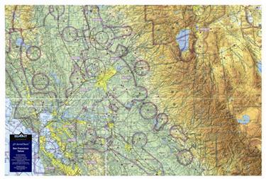
This 3D FAA Sectional aeronautical chart covers the central California area from San Francisco to Reno/Lake Tahoe, and includes Yosemite and Mammoth.
The precisely molded 3D shape allows pilots to see and feel the terrain shape and clearly understand how it relates to the airspace and flight. Pilots will value referencing this chart for flight planning, training, and as a general conversation piece, whether hung on a wall of an office, hangar, or home. This chart is made with a digital inkjet printing process on a rigid plastic film, which is then molded to a precise terrain model.
The precisely molded 3D shape allows pilots to see and feel the terrain shape and clearly understand how it relates to the airspace and flight. Pilots will value referencing this chart for flight planning, training, and as a general conversation piece, whether hung on a wall of an office, hangar, or home. This chart is made with a digital inkjet printing process on a rigid plastic film, which is then molded to a precise terrain model.
Отзывы Оставить отзыв
Вопросы и ответы
Вопросы отсутствуют.
Отзывы ещё не добавлены