3-D AERONAUTICAL CHART - SOUTHERN SIERRA


13 950
₽
Арт.
13-09597
Описание
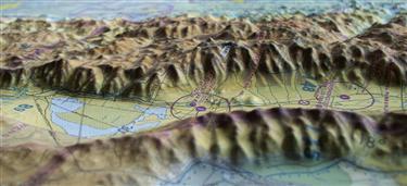
This 3D FAA Sectional aeronautical chart covers the high Southern Sierra Nevada Mtns, from Yosemite and Mammoth to Bakersfield and Mojave.
The precisely molded 3D shape allows pilots to see and feel the terrain shape and clearly understand how it relates to the airspace and flight. Pilots will value referencing this chart for flight planning, training, and as a general conversation piece, whether hung on a wall of an office, hangar, or home.
The precisely molded 3D shape allows pilots to see and feel the terrain shape and clearly understand how it relates to the airspace and flight. Pilots will value referencing this chart for flight planning, training, and as a general conversation piece, whether hung on a wall of an office, hangar, or home.
Отзывы Оставить отзыв
Вопросы и ответы
Вопросы отсутствуют.
Отзывы ещё не добавлены