3D AEROCHART PORTLAND - PACIFIC NORTHWEST


13 950
₽
Арт.
13-11714
Описание
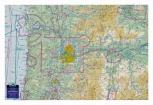
This 3D sectional wall chart is precisely molded into the true shape of Portland and southern Washington and northern Oregon terrain. This unique chart covers from the Pacific Ocean across the high mountains and to the eastern plains -- over 238 miles of dramatic topography. Displayed on a wall of a home, office or hangar, these 3D charts make for a striking display of the mountainous terrain and how the hazardous high terrain relates to aviation/airspace. Northwest mountain pilots will study this chart again and again to review past flights or plan new ones.
Made with a digital inkjet printing process on a rigid plastic sheet, which is then molded to a precise terrain model.
Отзывы Оставить отзыв
Вопросы и ответы
Вопросы отсутствуют.
Отзывы ещё не добавлены