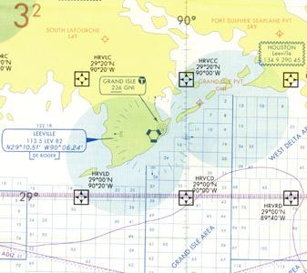
AERONAV IFR GULF OF MEXICO WEST CHART


4 950
₽
Арт.
13-08004
Описание
IFR Gulf of Mexico Chart is designed for helicopter operations. These 5-color charts depict an IFR GPS waypoint grid system that aids in the direct routing to oil platforms in the Gulf. NAVAIDs and airport data are shown on this chart along with special use airspace and oil lease block information.
The IFR Gulf of Mexico West chart depicts the west side of the IFR Gulf of Mexico Vertical Flight Reference Chart with an additional 2½ degrees of coverage on the back.
Chart: Scale 1 inch = .86nm/1:500,000; 45 x 36 inches flat or 5 x 9 inches folded. Revised annually.
Отзывы Оставить отзыв
Вопросы и ответы
Вопросы отсутствуют.
Отзывы ещё не добавлены