AVMAP ULTRA - EFIS

299 700
Арт.
11-12004
Описание
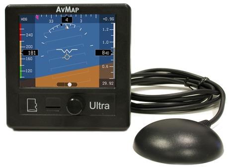
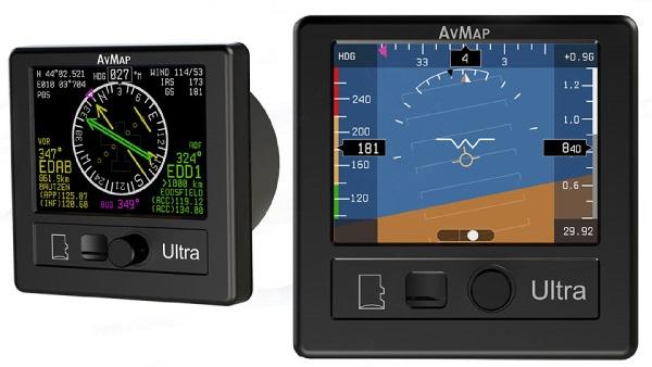
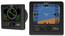
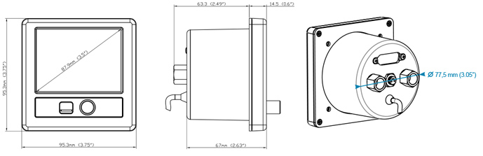
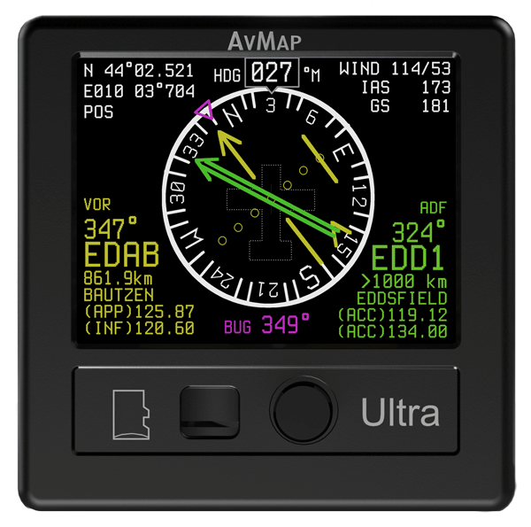
AvMap Ultra is a stand alone EFIS with a 3.5” ultra bright LCD display. The unit is compact (only 63.3 mm /2.49” of installing depth) and ultra light: only 230 g (8.1 Oz)!
 
Designed for light-sport, ultralight and experimental aircraft
 
 
Ultra light: only 8.1 oz
Ultra compact: only 2.49” of installing depth, and only 3.74” x 3.74” of external frame
Ultra bright: 3.5” ultra bright LCD display with 500 cd/m2 brightness


Ultra powerful, packed with everything you need

  • 3.5” ultra bright LCD
  • GPS
  • Solid state 3-axis gyro
  • 3-axis accelerometer
  • 3-axis magnetic field sensor
  • Pitot and Static air data sensors
  • UAV motion processor and sensor fusion software
  • Preloaded with Jeppesen database (APT, VOR, NDB)

AvMap Ultra EFIS connects to the aircraft Pitot – Static system

When connected to the Pitot-Static, Ultra provides Air Data and advanced performance!


PFD and HSI pages

The AvMap Ultra can display on the 3.5” LCD two different pages: PFD and HSI.
Change Page by using the rotor knob.
       

PFD page


HSI page

 
The PFD screen displays the ADAHRS data: Air Data, Attitude, Heading Reference System
The HSI screen display: Current position, Heading Distance, Direction, Radials relative to reference navigation points, Approximate wind data.


Your Navigation back-up!

The AvMap Ultra also provides navigation back-up: in the HSI screen you can select from the preloaded Jeppesen Database an Airport, a VOR station or NDB transmitter as your navigation point.

The Ultra EFIS contains an internal world magnetic model that allows it to calculate the local magnetic deviation and dip. The Ultra EFIS can calculate current position and ground speed even in the absence of GPS.

Отзывы Оставить отзыв

Отзывы ещё не добавлены

Вопросы и ответы
Can this AvMap Ultra EFIS be the primary PFD for an experimental aircraft? Can it drive an auto pilot? Or should I think of this as backup EFIS only?

Avmap recommends this EFIS as a backup instrument. It is not capable of driving an auto pilot as of 8/27/15.

I like the size of this Avmap Ultra EFIS. I am wanting a back-up EFIS, but I would also like to feed my Garmin GTN750 into the HSI. Can I do this? I am fully aware that it has its own GPS, but I would like to feed it with the certified GPS for IFR.

No, you cannot. The Avmap Ultra is only approved for use in experimental aircraft. IFR GPS backup is not available. See part number 10-05081 for an approved backup attitude indicator.

Does the Jeppesen database preloaded on the Avmap Ultra EFIS include Australian data?

Unit is preloaded with North America Jeppesen POIs (APT, VOR, NDB). Other coverages (Europe-Africa, South America, Asia-Australia) can be ordered from AvMap.

Does this unit have an internal battery that will operate the efis in the event of an external power failure?

This unit does not include an internal back-up battery.

Will this device work as an encoder for Stratus transponder 11-14466?

No, this cannot be used as an encoder.

Can this be installed in a Citabria for instrument training?

No, this is intended for use in experimental aircraft only.

Is the Avmap Ultra considered a portable device?

No, this unit is installed in the panel.

Got to ask, with it's NMEA 183 output I presume it can drive an auto-pilot?

The Ultra EFIS comes with 2 RS232 connections both can be enabled for sending out data to external devices (autopilot).

Is the GPS receiver included with the Avmap Ultra EFIS?

Yes, the GPS receiver is included with part # 11-12004

Does the AvMap Ultra EFIS include the harness?

No, the harness is not included with part # 11-12004. Only includes a 1.5 meter cable

Can this AvMap Ultra EFIS be used as a back up ADAHRS to connect to the Advanced Flight Systems 5000 series EFIS?

Not in certified aircraft. This can only be used in experimental aircraft.

I would like to know if the HSI function displays TO - FROM like standard VOR indicators? Thanks!

Per User and Installation Manual - Page 19: The VOR indicator is complete, with course deviation indicator (CDI) and to/from flag.

The overview states that the instrument requires a vertical panel. Sonex aircraft have an angled panel. Is there sufficient adjustment to effectively install this instrument in my Sonex?

The unit has the function that allows you to calibrate the unit for horizon alignment.

Can the AVmap take serial inputs from an existing GPS?

The unit comes with its own GPS receiver. There is no mention of connecting to an external GPS.