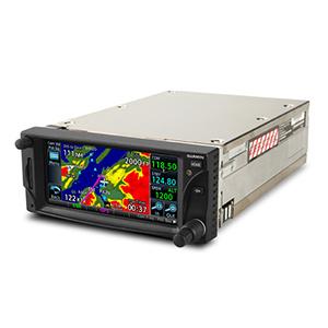
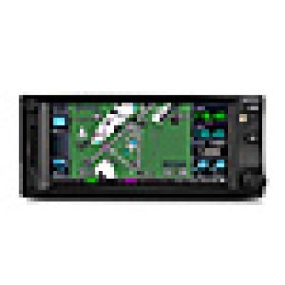
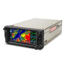
GARMIN GTN 635 GPS / COM SYSTEM USA WITH HARNESS FOR EXPERIMENTAL AIRCRAFT


2 891 700
₽
Описание
Note: Per Garmin, even though this product is certified, we can only sell over the counter to experimental aircraft (must verify) with wire harness. For certified aircraft, you will have to fly to a Garmin install dealer .
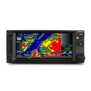
The 2.64" GTN 635 puts high resolution terrain mapping, graphical flight planning, multiple weather options and traffic display right at your fingertips. GTN 635
Touch & Go
With its revolutionary touchscreen interface, GTN 635 puts primary functions just a few taps away. Pan across the map screen by swiping your finger across the 4.9" high-resolution TFT display, and enter waypoint data with the onscreen alphanumeric entry. Raised grips in the bezel and a shelf across the lower edge of the display serve as gripping points in both smooth and turbulent flight conditions. Traditional concentric knobs are also available for data input. If you have a GNS 430W/530W, active flight plans automatically crossfill from the GTN to the GNS, or just manually crossfill user waypoints between devices.
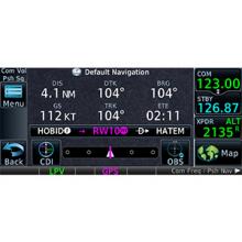
Navigate with Ease
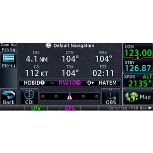
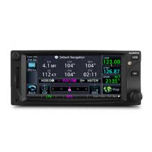
Edit your entire route using the map screen and enter new waypoints or modify existing ones, and load Victor and jet airways. A handy "rubber band" feature lets you grab any leg of your flight plan route or direct-to and move it to accommodate a deviation or ATC amendment to your flight plan. Enter your most recently visited or nearest airports as waypoints and Direct To destinations.
The robust 15-channel GPS receiver generates 5 position updates per second. This SBAS/WAAS-certified technology allows you to fly GPS-guided LPV glidepath instrument approaches down to as low as 200 ft. In addition, precise course deviation and roll steering outputs can be coupled to select autopilots so that IFR flight procedures may be flown automatically. This includes all ARINC 424 leg types, except RF legs. (For example, when coupled with a G500/G600 flight display, the aircraft can fly fully coupled missed approaches, including heading legs.)
Make Communication a Breeze
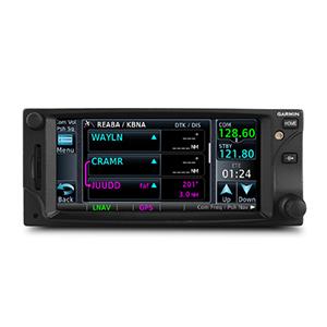
A fully certified, 2,280-channel VHF communications transceiver provides a standard 10 W (or optional 16 W) of power output. The system is pilot-selectable to both 25 kHz and 8.33 kHz channel spacing. Set your standby Com frequency simply by touching the onscreen number pad. Another touch of the screen switches your active and standby frequencies. Recent and favorite user frequencies also are a breeze to access. For added safety, holding down the volume knob will automatically dial in the emergency frequency.
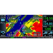
See More Than Ever Before
GTN 6d5 brings enhanced situational awareness to your cockpit. With high-resolution terrain mapping including topography features, cities, airports, terminal areas and SUAs and optional Class B TAWS alerting, youll find your way around the airspace safely and with ease. Smart Airspace automatically highlights airspace close to your current altitude and de-emphasizes airspace away from the current altitude. The system even allows you to load and follow Victor and jet airways. On the ground, built-in SafeTaxi airport diagrams give you geo-referenced runways, taxiways, FBOs and hangars available in either the U.S. or Europe.
Add Traffic, Weather & More
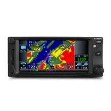
The dual-link GDL 88 allows the GTN 635 to display up to 60 ADS-B traffic targets. TargetTrend relative motion technology offers pilots a faster way to judge the direction and closure rate of intruding targets in relation to their aircrafts position. And unique SURF technology supports the display of ADS-B-equipped surface targets on SafeTaxi airport diagrams, including taxiing aircraft and ground vehicles. GDL 88 can also receive the FAAs subscription-free FIS-B weather broadcasts that include graphical NEXRAD radar information, as well as NOTAMs, METARs and TAFs. GTN gives GDL 88 with the WAAS position source required for ADS-B, so a WAAS version of the GDL 88 is not required. Consider adding a Traffic System to compliment the GDL 88 to provide the best possible traffic coverage from now until 2020.
Couple the system with a GDL 69 series datalink receiver to receive XM MX Satellite Weather and SiriusXM Satellite Radio (subscriptions required). An optional GSR 56 provides World Wide Weather data virtually anywhere on the globe, as well as the ability to make and receive phone calls and send and receive texts messages while in the air.
And because the GTN 635 can control the GTX 33 remote transponder, a GTN 635 installation could also save you valuable panel space.
Stay Up to Date The GTN 635 features a front-loading SD card reader, so you can easily update your databases. PilotPak database bundles are now available on a single aircraft basis, saving you money and simplifying the update process.
The 2.64" GTN 635 puts high resolution terrain mapping, graphical flight planning, multiple weather options and traffic display right at your fingertips. GTN 635
Touch & Go
With its revolutionary touchscreen interface, GTN 635 puts primary functions just a few taps away. Pan across the map screen by swiping your finger across the 4.9" high-resolution TFT display, and enter waypoint data with the onscreen alphanumeric entry. Raised grips in the bezel and a shelf across the lower edge of the display serve as gripping points in both smooth and turbulent flight conditions. Traditional concentric knobs are also available for data input. If you have a GNS 430W/530W, active flight plans automatically crossfill from the GTN to the GNS, or just manually crossfill user waypoints between devices.
Navigate with Ease
Edit your entire route using the map screen and enter new waypoints or modify existing ones, and load Victor and jet airways. A handy "rubber band" feature lets you grab any leg of your flight plan route or direct-to and move it to accommodate a deviation or ATC amendment to your flight plan. Enter your most recently visited or nearest airports as waypoints and Direct To destinations.
The robust 15-channel GPS receiver generates 5 position updates per second. This SBAS/WAAS-certified technology allows you to fly GPS-guided LPV glidepath instrument approaches down to as low as 200 ft. In addition, precise course deviation and roll steering outputs can be coupled to select autopilots so that IFR flight procedures may be flown automatically. This includes all ARINC 424 leg types, except RF legs. (For example, when coupled with a G500/G600 flight display, the aircraft can fly fully coupled missed approaches, including heading legs.)
Make Communication a Breeze
A fully certified, 2,280-channel VHF communications transceiver provides a standard 10 W (or optional 16 W) of power output. The system is pilot-selectable to both 25 kHz and 8.33 kHz channel spacing. Set your standby Com frequency simply by touching the onscreen number pad. Another touch of the screen switches your active and standby frequencies. Recent and favorite user frequencies also are a breeze to access. For added safety, holding down the volume knob will automatically dial in the emergency frequency.
See More Than Ever Before
GTN 6d5 brings enhanced situational awareness to your cockpit. With high-resolution terrain mapping including topography features, cities, airports, terminal areas and SUAs and optional Class B TAWS alerting, youll find your way around the airspace safely and with ease. Smart Airspace automatically highlights airspace close to your current altitude and de-emphasizes airspace away from the current altitude. The system even allows you to load and follow Victor and jet airways. On the ground, built-in SafeTaxi airport diagrams give you geo-referenced runways, taxiways, FBOs and hangars available in either the U.S. or Europe.
Add Traffic, Weather & More
The dual-link GDL 88 allows the GTN 635 to display up to 60 ADS-B traffic targets. TargetTrend relative motion technology offers pilots a faster way to judge the direction and closure rate of intruding targets in relation to their aircrafts position. And unique SURF technology supports the display of ADS-B-equipped surface targets on SafeTaxi airport diagrams, including taxiing aircraft and ground vehicles. GDL 88 can also receive the FAAs subscription-free FIS-B weather broadcasts that include graphical NEXRAD radar information, as well as NOTAMs, METARs and TAFs. GTN gives GDL 88 with the WAAS position source required for ADS-B, so a WAAS version of the GDL 88 is not required. Consider adding a Traffic System to compliment the GDL 88 to provide the best possible traffic coverage from now until 2020.
Couple the system with a GDL 69 series datalink receiver to receive XM MX Satellite Weather and SiriusXM Satellite Radio (subscriptions required). An optional GSR 56 provides World Wide Weather data virtually anywhere on the globe, as well as the ability to make and receive phone calls and send and receive texts messages while in the air.
And because the GTN 635 can control the GTX 33 remote transponder, a GTN 635 installation could also save you valuable panel space.
Stay Up to Date The GTN 635 features a front-loading SD card reader, so you can easily update your databases. PilotPak database bundles are now available on a single aircraft basis, saving you money and simplifying the update process.
Features
Features
- menu-driven graphical interface on color LCD touchscreen display
- feature-rich MFD capabilities: moving map, airways, approaches and more
- GPS TSOd to C146c, authorized for Class 1,2,3 (LPV)
- GPS WAAS-certified to Gamma-3 approach capability
- WAAS-corrected GPS signal accuracy to 1 M RMS
- graphical flight planning (including airway navigation)
- VHF COMM transceiver: 8.33 or 25 kHz channel spacing
- com transmit power: 10 W standard, 16 W optional
- extensive optional interface capabilities: lightning, weather, traffic and TAWS-B terrain alerting
- integrated control/display for remote transponder
- flight control system interface for select autopilots
- optional XM WX Satellite Weather and SiriusXM Satellite Radio
- SafeTaxi airport diagrams
- award-winning product support and 2-year warranty
| Арт. | MPN | Описание | Цена | Add to cart form |
|---|---|---|---|---|
| 11-12958
|
ASA-00173-CU
|
GARMIN GTN 635 KIT W/ EXP CUSTOM HARNESS
|
$
9 710
|
|
| 11-11282
|
ASA-00172-SU
|
GARMIN GTN 635 GPS / COM SYSTEM USA WITH HARNESS FOR EXPERIMENTAL AIRCRAFT
|
$
9 639
|
Отзывы Оставить отзыв
Вопросы и ответы
Вопросы отсутствуют.
Отзывы ещё не добавлены