|
Note: USA Database Coverage Only.
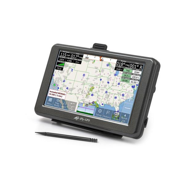
The iFly 520 Ultra-Portability with Unmatched Value!
The iFly 520 brings forth a new level of value boasting versatility and portability with internal power in a smaller 5 form factor. Each iFly is a robust dedicated aviation GPS built for the harsh elements that iPads cant support. Superior reception, extreme operating temperature ranges pilots need at a fraction of the competitions priceeven the updates are affordably priced. Save more, Fly more!
Sunlight Readability
Like its big brother, the iFly 520 is sunlight readable and provides both VFR and IFR situational awareness in a simple-to-use 5 Touchscreen. Perfect for bright cockpits. Enjoy more flight timewith the most affordable Sunlight-Readable GPS on the aviation market.
Untethered Power
The new 5 design accommodates the internal lithium-ion battery for cord free flying up to 2 hours when ship power is not available. The 520 is the perfect ultra-portable GPS for any pilots flight bag or a backup option.
iFly Streets Add-On
Go straight from the runway to the highway with iFly Streets, a full-featured road navigation tool. Detailed voice-guided directions, 3D visuals including Lane Guidance, Street Signs, Buildings and Landmarks make any trip a simple task. Find fast travel details and more with "Find a Place".
AutoTaxi+ with RealView
Automatically transition to and from the Airport Diagram upon takeoff and landing. The iFly adds the + with over 12,600 Realview airports. If no official Airport Diagram is available, AutoTaxi+ uses the RealView Image. RealView also makes it possible to see both public and private airports before you arrive. Know the airport like a pro!
Simplicity
For All - VFR and IFR Pilots!
Advanced Flight Planning
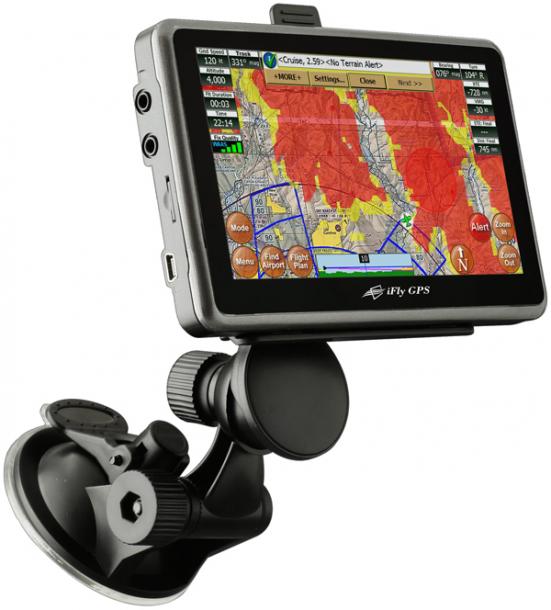
Plan your next flight on official VFR and IFR charts with access to public and private airports. Charts are adjustable to your liking and presented in a choice of Day or Night modestaying comfortable for all eyes. Rubber Band route planning is as simple as touching and dragging your route line to the desired waypoints, you can even plan for vertical terrain. Flight planning has never been so easy!
Simply Navigate
While in flight the iFly GPS presents your position over official charts with un-paralleled clarity due to our extensive optimization process. A wealth of information is available with a touch of the screen; everything from Pre-Flight Weather to loading a past flight or a saved route. Our Instruments Page and Active Alert System keeps you visually and audibly informed about upcoming airspaces, terrain and more. Total iFly confidence!
Weather and TFRs
The Pre-Flight option using iFly Connect grabs the latest TAF, METAR, Winds Aloft, TFRs and other data before takeoff for reference in flight. Take confidence knowing you have the latest Weather and TFR information. Ready for Take-Off!
Updating is a Snap!
With several simple options to update, the iFly GPS makes updating a breeze with iFly Connect or a USB Flash Drive. Updating is supported via PC or MAC, we also offer an Update-by-Mail program. With our affordable VFR and IFR Subscriptions, youll have more fun moneyonly $69/yr for VFR and $109/yr for IFR.
Active Alert System
As you fly, the iFly GPS uses its Active Alert System to monitor and generate warnings of approaching concerns. Configurable by airspace type, distance, altitude bufferreceive warnings based on your flying style with comprehensive alerting in one central location. Other key alert types include:
- Airspace Warnings
-
Obstruction Warnings
|
- Terrain Warnings
- Vertical Speed Targets
|
Take your next adventure with the iFly 520. |
Отзывы ещё не добавлены